

€ 22,24 € 2,99 verzendkosten Totaal € 25,23

Gesponsorde links
|
|
22,24 |
Naar shop
|

|
22,99 |
Naar shop
|

|
22,99 |
Naar shop
|
| VERGELIJK ALLE AANBIEDERS (3) | ||
 Beschrijving
Vergelijk aanbieders (3)
Gesponsorde links · Sommige shops betalen ons een vergoeding
€ 22,24 € 2,99 verzendkosten Totaal € 25,23
€ 22,99 Gratis verzending
€ 22,99 Gratis verzending
Winkels met andere maten
Beschrijving
(1)
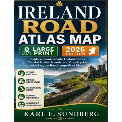
IRELAND ROAD ATLAS MAP - 2026 EDITIONExplore Ireland by road with clear, easy-to-read large-print maps designed for confident route planning and discovery.From dramatic Atlantic coastlines and winding countryside roads to historic cities, charming towns, islands, and scenic rural landscapes, Ireland offers an extraordinary variety of places to discover. This Ireland Road Atlas Map brings the country's major road networks and destinations together in a practical format for travelers, road trippers, and anyone who enjoys exploring Ireland by car.Inside, you'll find: - Easy-to-read large-print road maps for clearer navigation and route planning- Major roads, regional routes, and local connections- Historic cities and towns across Ireland- Scenic coastal routes and countryside roads- Island and ferry-connected destinations- The Wild Atlantic Way and other memorable driving corridors- Ireland's Ancient East and historic landscapes- Northern coastal routes and the Causeway Coast- Dublin and the Midlands with practical hub routes- Themed routes covering literary, whiskey, sporting, and island experiences- Useful route-planning information for short trips and extended road journeysWhether you are planning a weekend road trip, a longer driving holiday, or simply want a detailed visual reference to Ireland's roads and landscapes, this atlas helps you see the bigger picture and plan your journey with greater confidence.Discover Ireland one road at a time-from bustling cities and historic landmarks to rugged coastlines, peaceful countryside, and beautiful island routes.
 Prijshistorie
* Prijshistorie bevat geen data van Amazon, Amazon Marketplace.
Prijzen voor het laatst bijgewerkt op:
 Gerelateerde resultaten
 Productspecificaties


